|
Ernie,
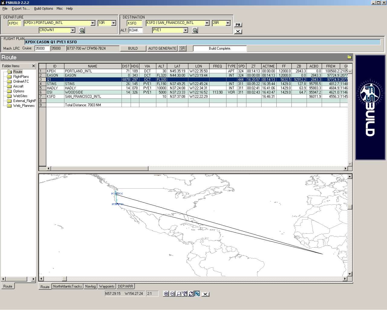
I have been using the web site to get real world flight plan's and have been coping them into FSBuild 2.2.2 to export them to the various aircraft flight plans. I ran into my first real flight stopper with the airway "Q1" used by all airlines on flights from KPDX (Portland, OR) to KSFO (San Francisco, CA). This is the route filed by UAL, ASA, Horizon, Air West, etc. "EASON Q1 PYE.
Looking at the latest FSB_awy2.txt file dated 2/8/2006 I have these entries:
Q1 --- EL 64.081111 -21.770833 B
Q1 --- SOGID 64.152500 -21.067500 B
Q1 --- THORI 64.340000 -19.000000 B
Q1 --- KOBBI 64.548889 -16.155833 B
Q1 --- KLAKI 64.655556 -15.770000 B
Q1 --- KELDU 64.881111 -15.194167 B
Q1 --- VA 65.109525 -14.596136 B
Q1 --- ES 65.238481 -14.452042 B
Q1 --- ELMAA 47.148041 -123.409550 B
Q1 --- ERAVE 46.909722 -123.401667 B
Q1 --- EASON 44.500000 -123.328889 B
Q1 --- EBINY 42.480556 -123.250181 B
Q1 --- ENVIE 41.335833 -123.208889 B
Q1 --- ETCHY 39.091111 -123.134722 B
Q1 --- PYE 38.079757 -122.867828 B
As you can see from the LAT/LON entries, this airway is obviously in two different locations at the same time. But the main problem is that there also appears to be a NAV (NDB) point with the same name but the program does not try to use this NDB and routes me via Africa instead: (see attached screen shot)
Q1 TADOULE_LAKE N58:43:36 W98:30:01 NDB 389.0
This is NOT the Q1 showing up on my route. It is located at N00.000.00 W00.000.00. Also Q1 is listed in the fsb_nawy_dup.txt and according should show up as an airway instead of a waypoint or nav aid.
Is there any way to make the entries use an airway instead of a NAV point?
Thanks,
Steve Park
| Attachments: |

Image_060426_102927.jpg [ 154 KiB | Viewed 6084 times ]
|
|


